e-ISSN: 2215-3896.
(Enero-Junio, 2022). Vol 56(1)
DOI: https://doi.org/10.15359/rca.56-2.1
Open Acces: www.revistas.una.ac.cr/ambientales
e-Mail: revista.ambientales@una.cr
Licencia: CC BY NC SA 4.0
Estimates of jaguar (Panthera onca) population density in the South American Greater Madidi-Tambopata Landscape
Estimaciones de la densidad poblacional del jaguar (Panthera onca) en el Gran paisaje de Madidi-Tambopata en Suramérica
Guido Marcos Ayala1, María Estela Viscarra2, Carlos Fonseca3, Robert Benedict Wallace4
[Received: June 4, 2021, Accepted: March 3, 2022, Revised: April 13, 2022, Published: July 1, 2022]
Abstract
[Introduction]: The jaguar (Panthera onca) is the largest cat in the Americas, and due to vast connected forests, the Amazon currently holds the largest jaguar populations. [Objective]: We present jaguar population density estimates for seven sites in the Great Madidi-Tambopata Landscape in northwestern Bolivia and southeastern Peru. [Methodology]: Data collection occurred from 2001 to 2008, using between 26 to 118 camera trap stations distributed in polygons between 37 to 355 km2 in extent, active from 29 to 75 days at each study site. [Results]: We identified a total of 63 individuals across all sampling sites. The estimated capture rate for each sampling site ranged from 0.18 to 2.81 independent events / 100 trap nights. The jaguar density estimates with SCR models ranged from of 0.1 to 2.39 individuals / 100 km2, and derived CAPTURE (MMDM) population density estimates using a regional buffer (5.76 km, n = 19), were between 0.52 and 2.86 individuals / 100 km2. [Conclusions]: These results are especially relevant for the development of conservation strategies and evaluations for this threatened species, and also underline the importance of the transboundary Greater Madidi-Tambopata Landscape as a population stronghold for jaguars in the region.
Keywords: Bolivia; camera traps; capture-recapture; mean distance; Peru.
Resumen
[Introducción] El jaguar (Panthera onca) es el felino más grande de América y debido a los vastos bosques conectados en la Amazonía tiene actualmente las mayores poblaciones de esta especie. [Objetivos]: Estimamos la densidad de jaguares para 7 sitios en el Gran Paisaje Madidi-Tambopata en el noroeste de Bolivia y el sureste de Perú. [Metodología] La toma de datos fue desde el 2001 al 2008, utilizando entre 26 y 118 estaciones de cámaras trampa distribuidas en polígonos entre 37 y 355 km2 de área muestreada, activas durante 29 a 75 días en cada sitio de estudio. [Resultados]: Identificamos un total de 63 individuos entre todos los sitios de muestreo. La tasa de captura estimada para cada sitio de muestreo osciló entre 0.18 y 2.81 eventos independientes / 100 trampas noche. Las estimaciones de densidad de jaguar con modelos SCR variaron de 0.1 a 2.39 individuos / 100 km2 y las estimaciones de densidad de población calculados con CAPTURE (MMDM) utilizando una zona de amortiguamiento regional (5.76 km, n = 19), estuvieron entre 0.52 y 2.86 individuos / 100 km2. [Conclusiones]: Estos resultados son especialmente relevantes para el desarrollo de estrategias de conservación y evaluaciones para esta especie que actualmente está siendo amenazada, también subrayan la importancia del paisaje transfronterizo del Gran Madidi-Tambopata como un bastión poblacional de jaguares en la región.
Palabras clave: Bolivia; cámaras trampa; captura-recaptura; distancia media máxima; Perú.
The jaguar (Panthera onca) is the largest felid in the Neotropics and, for many, it is the most powerful conservation symbol of the Amazon (Sunquist & Sunquist, 2002). Due to its individually large spatial requirements and key ecological role as the principal predator of the Neotropics, the jaguar is also considered an umbrella species (Thornton et al., 2016; Jędrzejewski et al.,2018), and its absence would cause trophic cascades, impacting prey populations, and affect the overall ecosystem dynamics (Cavalcanti & Gese, 2009). Historically, the jaguar was present from the southeastern United States, through Central America and South America, as far south as the Argentine Patagonia, covering an area of 19 921 440 km2 (Rabinowitz & Nottingham, 1986; Cuyckens et al., 2017). However, it currently occupies approximately 57 % of the historical distribution area (Jędrzejewski et al., 2018).
Globally, the jaguar is categorized as Near Threatened (NT) by the International Union for the Conservation of Nature (IUCN: Quigley et al., 2017), however, if conservation actions do not minimize threats, jaguars could move to the threatened category in the near future.
Currently, jaguars are considered regionally threatened in a large part of their range, mainly due to: a) habitat destruction, b) reduction in abundance of their main prey, c) persecution due to human-wildlife conflicts, and since 2014, d) hunting for illegal wildlife trafficking of jaguar body parts, especially fangs, but also claws, skin and others, for international markets (Morcatty et al., 2020; Negrões et al., 2017; Nuñez & Aliaga-Rossel, 2017; Porfirio et al., 2016).
The Amazon region is considered the primary jaguar population stronghold across its range, because it retains a large, continuous block of habitat with a high probability of long-term survival (Sanderson et al., 2002). The tropical rainforest lowlands are the largest ecoregion within the Amazon, spanning five countries including Brazil, Bolivia, Colombia, Ecuador and Peru (Tobler et al., 2013). The Greater Madidi-Tambopata Landscape lies in northwestern Bolivia and southeastern Peru, contains some of the most biodiverse protected areas in the world, and as a transboundary area expands opportunities to protect species with large spatial requirements such as the jaguar.
Population density estimates are a fundamental requirement for conservation management evaluation, as they provide an idea of population size, ballpark estimates to assess the need for conservation interventions (Jędrzejewski et al., 2018; Maffei et al., 2004). The camera trap methodology and satellite telemetry technology have dramatically improved knowledge about the jaguar in the last years contributing with studies that have estimated population densities, and shed more light on different ecology and behavior aspects in some of the most important ecosystems within the jaguar's range including the tropical forests of Central America (Moreira et al., 2008), the Pantanal wetlands (Silveira et al., 2010; Soisalo & Cavalcanti, 2006), the tropical dry forests of the Gran Chaco (Maffei et al., 2004), and the Atlantic forest of Brazil (Cullen et al., 2005). However, to date there are surprisingly few studies for the vast humid tropical forests of the Amazon which is by far the largest habitat for the jaguar (Silver et al., 2004; Tobler et al., 2013; Wallace et al., 2003).
Therefore, in this article, we present camera trap derived jaguar population density estimates from seven study sites in northwestern Bolivia and south-eastern Peru in one of the largest continuously protected regions in the Amazon: the transboundary Madidi-Tambopata Landscape. This study is one of the first on jaguar population densities in the western Amazon.
2.1 Study sites
The research was carried out at 7 sites, 6 in Bolivia and 1 in Peru within the Greater Madidi-Tambopata Landscape, a transboundary landscape in the Andean Mountain range, between northwestern Bolivia and southeastern Peru. This area covers approximately 142 530 km2 (Bolivia 106 810 km2, Peru 35 720 km2), and is characterized by an impressive altitudinal range (180 to 6 044 m a.s.l.), varied topography and climate that have resulted in diverse plant and animal communities and a high number of endemic species. Historically, diverse cultural groups settled in the Amazonian portion of the Tropical Andes, among them the Leco, Tacana, Araona, Ese Ejja, T'simane and Mosetene peoples. Together, these indigenous areas cover 42 000 km2. The conservation value of this landscape is particularly important as a transboundary area, ensuring the connectivity of ecosystems and the binational coordination of conservation efforts.
In Bolivia, sampling was carried out along some of most important rivers of the region: Tuichi, Hondo, Quendeque, Madidi, Heath, Undumo and Tequeje. All 6 Bolivian study sites were within the Abel Iturralde Province of the La Paz Department, 5 within the Madidi National Park and Natural Area of Integrated Management (PN ANMI Madidi), while the sixth site within the Tacana Indigenous Territory or TCO (Community Land of Origin). In Peru, sampling occurred along the Heath, Tambopata, Malinowski and Chuncho rivers, within the Tambopata Province, Madre de Dios Region, and within the Tambopata National Reserve and Bahuaja Sonene National Park (Figure 1).
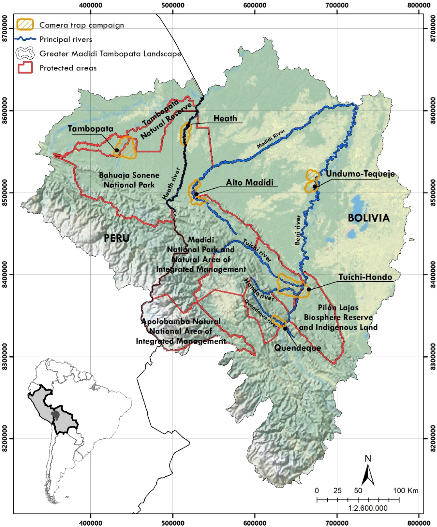
Figure 1. Location of 7 study sites with camera trap polygons in the Greater Madidi–Tambopata Landscape in northwestern Bolivia and southeastern Peru.
Figura 1. Ubicación de 7 sitios de estudio con polígonos de cámaras trampa en el Gran Paisaje Madidi-Tambopata en el noroeste de Bolivia y sureste de Perú.
The Amazonian study sites are mainly found in the sub-Andean foothill ecoregion, except for the Tequeje-Undumo site found in the pre-Andean Amazon forest and Moxos flooded savanna ecoregions, and the Heath site found in the Pando Amazon flooded forests and Moxos flooded savanna ecoregions (Ibisch et al., 2003).
The Tuichi and Hondo rivers are tributaries of the Beni River located in valleys adjacent to the final foothills of the Andes. The tropical forest vegetation is similar to those of the Beni floodplain (Fuentes, 2005). The Quendeque River is a smaller tributary further upstream on the Beni. These three sites lie completely within the Madidi protected area.
Alto Madidi is located on the Madidi River, a major tributary of the Beni River, at the very base of the final steep slopes of the Andean foothills. The forest is slightly taller than the Tuichi, Hondo and Quendeque, although the species composition is similar (De la Quintana, 2005; Fuentes, 2005). At Alto Madidi, one side of the river is within the Madidi protected area and the other side is within the Ixiamas Muncipal Protected Area.
The Heath River is in the extreme north of the Madidi protected area and represents the border between Bolivia and Peru, therefore, one side of the river is within Madidi and the other side in Bahuaja Sonene National Park in Peru. This site has various vegetation types including natural Amazonian savannas, Amazon terra firme rainforests with good drainage, riparian vegetation, and flooded forests with poor drainage that are strongly marked by recurrent floods. The forests are generally tall, with emergent trees reaching 45 m and a 25-35 m canopy (Fuentes, 2005).
The Tequeje and Undumo study site encompasses the rivers of the same name that flow into the Beni River further downstream within the Tacana Indigenous Land. This area has four vegetation types: Amazonian seasonal humid forest, riparian forest, seasonal flood savanna and wooded savanna (Ribera, 1992).
The Tambopata sampling site in Peru focused along the Tambopata, Malinowski, and Chuncho rivers between 200 and 500 meters above sea level. The Madre de Dios region is characterized by humid tropical forests with large trees exceeding 50 m in height and 5 m in diameter (CI-Perú, 1999).
2.2 Field surveys
Between 2001 to 2008, a total of 15 camera trap surveys were implemented, with a sampling design specifically aiming for jaguars (Cavalcanti & Gese, 2009; Maffei et al., 2011; Silver et al., 2004; Soisalo & Cavalcanti, 2006; Tobler et al., 2013; Wallace et al., 2003). All camera trap efforts were carried out during the dry season between July and October (Table 1). A variable number of camera trap stations (n = 26 - 118) (Table 1), were placed 1.6 to 2 km apart from each other, based on the minimum home range for a female jaguar of 10 km2 estimated by Rabinowitz & Nottingham (1986). Each station consisted of two cameras placed face to face so as to photograph jaguars from both sides, each set at 50 - 70 cm from the ground, with at least 3 - 4 m between the two cameras at each camera station (Noss et al., 2013).
Table 1. Detail of the jaguar camera trap study efforts for 7 sites in the Greater Madidi-Tambopata Landscape.
Cuadro 1. Detalle de los esfuerzos aplicados con trampas cámara para estudios de jaguar en 7 sitios de estudio en el Gran Paisaje Madidi-Tambopata.
|
Year |
Survey site |
Dates |
GPS local UTM |
N° Trap stations |
N° Effective days |
Camera trap nights |
Sampled polygon (km2) |
|
2001 |
Tuichi |
Aug - Nov |
636283 8391747 |
47 |
30 |
1 513 |
52.56 |
|
2002 |
Tuichi-Hondo |
Jul - Oct |
637226 8387900 |
66 |
56 |
2 116 |
213.49 |
|
2003 |
Quendeque |
Aug - Sep |
629584 8342331 |
32 |
29 |
1 108 |
37.09 |
|
2004 |
Upper Madidi |
Aug - Oct |
523814 8500612 |
26 |
34 |
1 138 |
110.55 |
|
2005 |
Heath |
Jul - Oct |
514756 8572464 |
63 |
50 |
1 813 |
103.09 |
|
2006 |
Undumo-Tequeje |
Aug - Oct |
672042 8514868 |
59 |
50 |
1 640 |
122.5 |
|
2007 |
Tambopata |
Jul - Nov |
436491 8550644 |
118 |
75 |
3 420 |
292.04 |
|
2008 |
Tuichi-Hondo |
Jul - Sep |
637599 8383253 |
77 |
50 |
2 123 |
354.87 |
Throughout the sampling years, three camera trap models were used: Camtrakker ® (Camtrakker, Watkinsville, Georgia, USA), DeerCam ® (DeerCam, Park Falls, Wisconsin, USA) and TRAILMASTER ® (TRAILMASTER, Kansas, USA), film cameras. The cameras were operating continuously for a period of 25 to 34 effective sampling days in the field with a minimum interval of three minutes between photographic events.
The camera trap stations were placed in the predominant habitats of each study area: a) beach, open areas along the main and secondary rivers; b) forest, located within the forest, often along animal trails, and on small streams within the forest; and c) pampa, open grassland locations.
2.3 Density estimation
Jaguar individuals were identified based on differences in spot and rosette patterns, and by sex when possible (Noss et al., 2013; Wallace et al., 2003). If a photo could not be clearly assigned to an individual, it was excluded from the density analysis.
To estimate jaguar population densities at the study sites, we applied the spatial capture-recapture (SCR) method using the SECR package in R version 3.6.3 (Royle et al., 2013). SCR models use spatial information from detections to estimate parameters with a half-normal detection function (probability of detection at the center of the home range g0 and motion parameter σ) (Tobler et al., 2013). Although spatially explicit models have been proven to be the best estimators, they tend to underestimate densities if they lack sufficient recaptures of jaguar individuals (Noss et al., 2012; Tobler & Powell, 2013). Thus, for comparative purposes with other studies and for sites with few individuals and recaptures, we also report population density estimates with non-spatial capture-recapture methods that estimate density by applying a buffer (Paviolo et al., 2008; Silver et al., 2004) using the CAPTURE program (Otis et al., 1978; Rexstad & Burnham, 1992).
As all study sites were sampling the same overall jaguar population and yet some individual study sites had few jaguar individuals with multiple captures, we calculated a regional buffer using the mean of all the maximum distances traveled (MMDM) by jaguars in different campaigns between 2001 and 2008 (n = 19) when estimating jaguar density using CAPTURE.
We also report the jaguar camera trap relative abundance indices (RAI), considering only independent events, namely records for the same individual separated by at least 24 hours. The indices were calculated following the recommendations of O'Brien et al., (2003). The Relative abundance index (RAI) was calculated through the capture rate expressed as the number of independent events per total number of traps night during the study and multiplied by 100 (O'Brien et al. 2003). The traps night are the days that the camera traps were active during the study.
We performed Spearman correlations (Rs) between the CAPTURE and SECR population density estimates to analyze the relationship between these estimators.
A total of 488 camera trap stations were placed on the ground, generating an effort of between 1 107 and 3 419.29 trap nights per sample site, and covering polygons of between 37.09 to 354.87 km2 (Table 1).
A total of 195 jaguar photographs representing 151 events and 113 independent events were obtained across the seven study sites. The relative abundance index (RAI) for the different study sites varied between 0.18 to 2.81 independent events / 100 trap nights (Table 2).
A total of 63 jaguars were identified: 27 adult males, 15 adult females, 1 juvenile male and 1 juvenile female, and 19 adults of unidentified sex. Tuichi-Hondo and Alto Madidi were the sampled sites with the highest number of captured individuals (12 and 15 individuals, respectively) (Table 2).
Table 2. Details of the number of photographs, independent events, individuals captured, recaptures, sex and relative abundance indices (RAI) of jaguars recorded with camera traps at 7 study sites in the Greater Madidi-Tambopata Landscape.
Cuadro 2. Detalle del número de fotografías, eventos independientes, individuos capturados, recapturas, sexo e índices de abundancia relativa (RAI) de jaguares registrados con cámaras trampa en 7 sitios de estudio en el Gran Paisaje Madidi-Tambopata.
|
Year |
Survey site |
Nº Photos |
Independent events |
Total individuals |
Re-captures |
Adult males |
Adult females |
Unidentified sex |
Juveniles |
RAI |
|
2001 |
Tuichi |
7 |
6 |
2 |
4 |
2 |
0 |
0 |
0 |
0.38 |
|
2002 |
Tuichi-Hondo |
37 |
20 |
12 |
7 |
6 |
2 |
3 |
1 |
0.94 |
|
2003 |
Quendeque |
12 |
7 |
4 |
3 |
3 |
0 |
1 |
0 |
0.62 |
|
2004 |
Upper Madidi |
54 |
32 |
14 |
17 |
7 |
5 |
2 |
0 |
2.81 |
|
2005 |
Heath |
14 |
8 |
6 |
2 |
1 |
3 |
1 |
1 |
0.44 |
|
2006 |
Undumo-Tequeje |
12 |
3 |
3 |
0 |
0 |
1 |
2 |
0 |
0.18 |
|
2007 |
Tambopata |
28 |
18 |
9 |
2 |
3 |
3 |
3 |
0 |
0.53 |
|
2008 |
Tuichi-Hondo |
31 |
19 |
12 |
3 |
5 |
1 |
6 |
0 |
0.91 |
|
Total |
195 |
113 |
63 |
37 |
27 |
15 |
19 |
2 |
The SCR density estimates were calculated with the null model (M0), and varied between 0.1 to 2.39 individuals / 100 km2 (Figure 2a). The SCR density for Undumo-Tequeje was not estimated due to a lack of recaptures. In Tambopata and Heath, the SCR density estimates were overestimated with high confidence limits, due to scarce recaptures (Table 3).
Table 3. SCR derived jaguar population estimates at 7 sites across the Greater Madidi-Tambopata Landscape.
Cuadro 3. Estimaciones de población de jaguar obtenidos con SCR en siete sitios en el Gran Paisaje Madidi-Tambopata.
|
Year |
Sampling Site |
Individuals |
g0 |
Sigma |
Density/100 km2 |
95% Confidence Limits |
|
2001 |
Tuichi |
2 |
0.008 |
1 436 |
0.10 ± 0.05 |
0.01 - 3.27 |
|
2002 |
Tuichi-Hondo |
9 |
0.003 |
5 550 |
1.56 ± 1.15 |
0.43 - 5.68 |
|
2003 |
Quendeque |
4 |
0.004 |
1 120 |
0.27 ± 0.04 |
0.03 - 2.50 |
|
2004 |
Upper Madidi |
14 |
0.014 |
4 263 |
2.22 ± 0.86 |
1.08 - 4.61 |
|
2005* |
Heath |
6 |
0.006 |
1 131 |
9.16 ± 7.47 |
2.26 - 37.10 |
|
2007* |
Tambopata |
9 |
0.002 |
2 475 |
6.16 ± 4.97 |
1.55 - 24.6 |
|
2008 |
Tuichi-Hondo |
8 |
0.004 |
3 219 |
2.39 ± 1.53 |
0.76 - 7.56 |
* Overestimated density due to low number of re-captures.
* Densidad sobreestimada debido al bajo número de recapturas.
The CAPTURE (MMDM) density estimates with the regional buffer varied between 0.52 to 2.34 individuals / 100 km2 (Figure 2b). Table 4 compares density estimates using site-specific buffers versus the regional buffer, with the latter reducing confidence limits density estimates for most sites.
Table 4. Jaguar density estimates obtained with CAPTURE (MMDM) at 7 sites across the Great Madidi-Tambopata Landscape using the specific buffer of each sampling site versus the regional buffer obtained from the mean maximum distance traveled (2001 - 2008).
Cuadro 4. Estimaciones de la densidad de jaguares obtenidas con CAPTURE (MMDM) en 7 sitios en el Gran Paisaje Madidi-Tambopata utilizando el buffer específico de cada sitio de muestreo versus el buffer regional obtenida de la distancia media máxima recorrida (2001 - 2008).
|
Sample specific MMDM |
Regional MMDM |
||||||
|
Year |
Sampling site |
Sample specific buffer (km) |
Area sampled (km2) |
Density/100 km2 |
Regional buffer (km) |
Area sampled (km2) |
Density/100 km2 |
|
2001 |
Tuichi |
11.84 |
935.47 |
0.21 ± 0.046 |
5.76 |
379.15 |
0.52 ± 0.14 |
|
2002 |
Tuichi-Hondo |
9.51 |
1085.63 |
1.11 ± 0.58 |
5.76 |
671.23 |
1.78 ± 0.50 |
|
2003 |
Quendeque |
9.55 |
600.37 |
0.83 ± 0.34 |
5.76 |
305.16 |
1.63 ± 0.92 |
|
2004 |
Upper Madidi |
4.54 |
465.66 |
3.65 ± 3.33 |
5.76 |
593.2 |
2.86 ± 0.82 |
|
2005 |
Heath |
1.92 |
191.64 |
3.65 ± 1.54 |
5.76 |
471.92 |
1.48 ± 0.83 |
|
2007 |
Tambopata |
4.16 |
635.01 |
2.52 ± 1.25 |
5.76 |
801.15 |
1.99 ± 1.09 |
|
2008 |
Tuichi-Hondo |
5.24 |
835.97 |
1.32 ± 0.1 |
5.76 |
897.25 |
2.34 ± 1.05 |
The SCR and CAPTURE density estimates were significantly correlated (Rs = 0.90, p = 0.037), and at sites with larger numbers of captured and recaptured individuals, such as Tuichi-Hondo (2002 and 2008) and the Upper Madidi, the density estimates using both methods were relatively similar (Figure 2).
Tuichi-Hondo had the highest calculated densities with both estimation programs, and there was an increase from 0.52 to 2.34 jaguars / 100 km2 between 2002 and 2008.
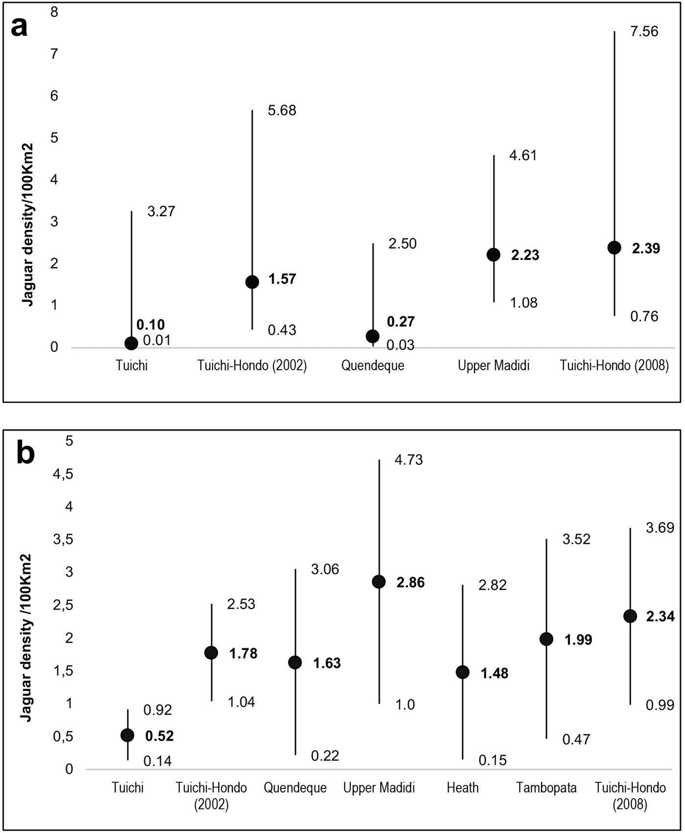
Figure 2. Jaguar density estimates using SCR (a) and CAPTURE (MMDM) (b) at the Greater Madidi-Tambopata Landscape.
Figura 2. Estimaciones de la densidad de jaguar obtenidas con SCR (a) y CAPTURE (MMDM) (b) en el Gran Paisaje Madidi-Tambopata.
4.1 Jaguar density
Both estimation methods produced similar density estimate ranges, with SCR estimating 0.10 - 2.39 jaguars / 100 km2 versus 0.52 - 2.86 jaguars / 100 km2 for CAPTURE (MMDM). These estimates are higher than those reported nearby in the Bolivian Chaco (0.31 - 1.82 jaguars / 100 km2; Noss et al., 2012), and it is half the density reported in neighboring southeastern Perú (4.4 jaguars / 100 km2; Tobler et al., 2013).
Our density estimates are higher than in Atlantic Forest in Argentina (0.49 - 0.93 jaguars / 100 km2; Paviolo et al., 2008), and northeastern Brazil (1.28 jaguars / 100 km2; Silveira et al. 2010), but lower than estimates for Guatemala (6.1 jaguars / 100 km2; Moreira, 2008), the Brazilian Pantanal (5.5 jaguars / 100 km2; Soisalo & Cavalcanti, 2006) and Belize (4.4 jaguars / 100 km2; Miller & Miller, 2005). However, it should be noted that many of the latter studies were calculated using HMDM and also sampled relatively small areas, both of which can lead to density overestimation (Noss et al., 2012; Tobler & Powell, 2013). Although our estimates are not the highest for the jaguar's range, they are valuable because they provide population data from one of the most unknown regions for the species.
4.2 Comparison of SCR vs MMMD estimates
SCR models are increasingly popular in ecology because they address some important criticisms of traditional capture-recapture methods related to heterogeneity in detectability, as well as the emergence of new technologies such as camera traps and non-invasive genetics (Sutherland et al., 2019). However, sparse data usually leads to imprecise estimates (Noss et al., 2012; Tobler & Powell, 2013), because SCR analyses require multiple detections of the same individuals at different locations in order to estimate the location of latent activity centers and generate a more accurate estimate. A common way to increase the size of the dataset is to prolong the sampling period, thus increasing both the proportion of individuals detected and the number of detections per individual (Noss et al., 2012). Thus, the main reason why SCR densities could not be calculated for all study sites was the relatively short sampling extension, which resulted in large confidence intervals, due to low recaptures and detection rates. Other factors, such as the size of the sampling area at some study sites and the use of film cameras, may have also influenced density estimates.
We observed that when using the MMDM, CAPTURE densities are closer to those calculated with SCR. For example, Alto Madidi has the highest MMDM density with CAPTURE (2.86 ± 0.8 jaguars / 100 km2) and the highest number of recaptures, and SCR produced very similar density estimates: 2.2 ± 0.8 jaguars / 100 km2 (Figure 2). These results suggest that sites with enough recaptures, produce similar density estimates for both analytical methods. However, in places where there are not enough recaptures, spatially explicit estimators tend to produce population densities with very high confidence limits. For example, at Heath and Tambopata, SCR derived density estimates of 9.16 ± 7.5 and 6.2 ± 4.9 jaguars / 100 km2, as compared to CAPTURE estimates of 1.48 ± 0.8 and 1.9 ± 1.1 jaguars / 100 km2 (Table 3). We believe that the regional buffer employed by us, permitted more robust density estimates when comparing with the ones that use a polygon buffer obtained within the specific trapping campaign, procedure followed by the majority of published CAPTURE density estimates (Maffei et al., 2004).
However, both density estimation methods have limitations and errors and only by comparing with other data such as radio-tracking and genetic, could we confirm an overestimation of the estimated densities. These results highlight that based on the data obtained, we should carefully look at the sampling design and data when choosing the density calculation method, and when reporting density estimates using different analytical methods.
4.3 Sex difference
In our study, we identified 63 individuals, of which 28 were male, 16 females and 19 unidentifiable (due to photographs with bad angles, and partial and blurred photographs).
We calculated the sex ratio of the proportion of jaguars where the sex could be differentiated, obtaining a sex ratio of 1.8:1 of males relative to females. Similar results were reported in several studies (Maffei et al., 2004; Silver et al., 2004). Females have smaller territories than males, and when with cubs they exhibit protective maternal behavior by selecting safer areas and reducing the use of exposed areas, thereby decreasing the probability of being photographed (Jędrzejewski et al., 2018; Moreira, 2008; Tobler et al., 2013).
In this study, due to the insufficient number of recaptures of male and female individuals, it was not possible to estimate density for the different sexes (Table 2), even with a pooled data from different years at the same site (e.g. Tuichi-Hondo 2002 and 2008).
4.4 Conservation implications
The jaguar is threatened by high deforestation rates stimulated by the growing demand for beef, soybean and other products, as well as extensive fires, increasing human population, and the recent demand for jaguar parts in an emerging illegal international trade (Morcatty et al., 2020; Nuñez & Aliaga-Rossel, 2017; Romero-Muñoz et al., 2020). These problems imply the need for transboundary actions for the conservation of this species, an approach that must go beyond geopolitical boundaries to maintain population connectivity (Mena et al., 2020; Thompson et al., 2020). In this context, our study reveals an important population of jaguars in the Greater Madidi-Tambopata Landscape, representing a stronghold jaguar population within the Amazon. Thanks to a transboundary conservation effort, and the combination of different neighboring and overlapping management systems such as national protected areas, municipal protected areas and indigenous territories, a very large percentage (ca. 60 %) of the 140 000 km2 landscape is protected, which will be essential for the survival of jaguars and the record-breaking biodiversity that coexists in this region. These characteristics favor conservation actions at the binational level that will also ensure connectivity to safeguard ecological processes and ecosystem services.
Our study reveals conservation relevant jaguar density estimates for the Bolivian and Peruvian Amazon rainforest, where there are few previously reported data. In addition, this study provides key information that can aid in the development of jaguar conservation strategies and monitor jaguar populations and that, at the longer term, will help us better understand their population dynamics and their interaction with other species.
The Greater Madidi-Tambopata Landscape Conservation Program of the Wildlife Conservation Society (WCS) is financed by the Gordon and Betty Moore Foundation (GBMF) and WCS. Specific financial support for jaguar camera trapping was provided by GBMF, Disney Wildlife Conservation Fund, Woodland Park Zoological Society, Liz Claibourne and Art Ortenberg Foundation, and WCS. Guido Ayala was partially supported between 2014 and 2020 by a Ph.D grant (SFRH/BD/52574/2014) from Fundação para a Ciência e a Tecnologia (FCT), Portugal. We would like to thank University of Aveiro (Department of Biology & CESAM) and to FCT/MCTES for the financial support (UIDP/50017/2020+UIDB/50017/2020), through national funds. We are grateful to the Bolivian Protected Area Service (SERNAP), the Bolivian Biodiversity and Protected Area Directorate (DGBAP), the Madidi and Tambopata protected area administrations. We also thank Edson Gonzales, Esteban Canare, Victor Hugo Cáceres, Jesús Duran, Fortunato Espinoza, and Juan Buchapi for support during camera trapping efforts. Special thanks to Professor Amadeu Soares for the support provided during Guido Ayala’s PhD. Thanks very much to all the park guards of Madidi National Park who have supported our activities on a number of occasions over the years. A special thanks to Ariel Reinaga for the support provided in the elaboration of maps.
7. Ethics and conflict of interest
The authors declare having fulfilled all relevant legal and ethical requirements during the study, as well as during the preparation of the manuscript. They also declare that there are no conflicts of interest of any nature, that all financial sources are fully and clearly mentioned in the acknowledgments section, and that they fully agree with the final edited version of the article.
Cavalcanti, S. & Gese, E.M. (2009). Spatial ecology and social interactions of jaguars (Panthera onca) in the southern Pantanal, Brazil. Journal of Mammals, 90(4), 395-945. https://doi.org/10.1644/08-MAMM-A-188.1
Conservación Internacional Perú. (1999). Complejidad y Fragilidad, la conservación y la exploración petrolera en Tambopata-Candamo. CI - Perú ediciones. Lima, Peru.
Cullen, Jr. Abreu, L. K. C., Sana, D. & Nava, A. F. D. (2005). Jaguars as landscape detectives for the upper Parana river corridor, Brazil. Natureza e Conservacao, 3, 43-58. https://www.researchgate.net/publication/282186446_Jaguars_as_landscape_detectives_for_the_upper_Parana_River_corridor_Brazil
Cuyckens, G. A. E., Perovic, P.G. & Herrán, M. (2017). Living on the edge: regional distribution and retracting range of the jaguar (Panthera onca). Animal Biodiversity and Conservation, 40(1), 71-86. https://doi.org/10.32800/abc.2017.40.0071
De la Quintana, D. (2005). Diversidad florística y estructura de una parcela permanente en un bosque amazónico preandino del sector del Río Hondo, Área Natural de Manejo Integrado Madidi (La Paz, Bolivia). Ecología en Bolivia, 40, 418-442. https://ecologiaenbolivia.com/documents/16Hondo40-3.pdf
Fuentes, A. (2005). Una introducción a la vegetación de la región de Madidi. Ecología en Bolivia, 40,1-31. http://www.mobot.org/MOBOT/Research/madidi/pdf/02Introduccin40-3.pdf
Ibisch, P. L., Beck, S. G., Gerkmann, B. & Carretero, A. (2003). Ecorregiones y ecosistemas. In: P. L. Ibisch & G. Mérida (Eds.), Biodiversidad: La Riqueza de Bolivia. Estado de Conocimiento y Conservación. (pp. 47–53). Editorial FAN. https://www.researchgate.net/publication/328028130_Biodiversidad_-_riqueza_de_Bolivia#:~:text=En%20Bolivia%20se%20encuentra%20un,es%20imprescindible%20para%20su%20supervivencia.
Jędrzejewski, W., Robinson, H. S., Abarca, M., Zeller, K. A., Velasquez, G., Paemelaere E. A. D., Goldberg, J. F., Payan, E., Hoogesteijn, R., Boede, E. O., Schmidt, K., Lampo, M., Viloria, A. L., Carreño, R., Robinson, N., Lukacs, P. M., Nowak, J. J., Salom-Perez, R., Castañeda, F., Boron, V. & Quigle, H. (2018). Estimating large carnivore populations at global scale based on spatial predictions of density and distribution - Application to the jaguar (Panthera onca). PLoS ONE, 13(3), e0194719. https://doi.org/10.1371/journal.pone.0194719
Maffei, L., Cuéllar, E. & Noss, A. (2004). One thousand jaguars (Panthera onca) in Bolivia's Chaco? Camera trapping in the Kaa-Iya National Park. Journal of Zoology, 262(3), 295-304. https://doi.org/10.1017/S0952836903004655.
Maffei, L., Polisar, J., García, R., Moreira, J. & Noss, A. (2011). Perspectives from ten years of jaguar (Panthera onca) camera trapping in Mesoamerica. Mesoamericana, 15(1), 49-59. https://www.researchgate.net/publication/269709076_Perspectives_from_ten_years_of_jaguar_Panthera_onca_camera_trapping_in_Mesoamerica_Perspectivas_de_diez_anos_de_estudios_con_trampas_camara_de_jaguares_Panthera_onca_en_Mesoamerica
Mena, J. L., Yagui, H., Tejeda, V., Cabrera, J., Pacheco-Esquivel, J., Rivero, J. & Pastor, P. (2020). Abundance of jaguars and occupancy of medium- and large-sized vertebrates in a transboundary conservation landscape in the northwestern Amazon, Global Ecology Conservation, 23 e01079. https://doi.org/10.1016/j.gecco.2020.e01079.
Miller, C. M. & Miller, B. (2005). Jaguar density in La Selva Maya. Report. Wildlife Conservation Society, Gallon Jug, Belize.
Morcatty, T., Macedo, J. C. B., Nekaris, K. A. I., Ni, Q., Durigan, C., Svensson, M. S. & Nijman, V. (2020). Illegal trade in wildcats and its link to Chinese‐led development in Central and South America. Conservation Biology, 34(6), 1525–1535. https://doi.org/10.1111/cobi.13498.
Moreira, J., McNab, R.B., García, R., Méndez, V., Ponce-Santizo, G., Córdova, M., Tun, S., Caal, T., & Corado, J. (2008). Densidad de Jaguares en el Biotopo Protegido Dos Lagunas, Parque Nacional Mirador Río Azul, Petén, Guatemala. Wildlife Conservation Society. Flores, Guatemala. 1-21. https://docplayer.es/60147300-Densidad-de-jaguares-en-el-biotopo-protegido-dos-lagunas-parque-nacional-mirador-rio-azul-peten-guatemala.html
Negrões, N., Arise, R., Asturizaga, K., Barboza, K., Fonseca, C., Ten, S., & Terán, M. (2016). Conflicto con jaguar (Panthera onca) en Bolivia: del daño al ganado a la percepción de riesgo. In: C. Castaño-Uribe, C.A. Lasso, R. Hoogesteijn & E. Payán-Garrido (Eds.), II Conflicto entre felinos y humanos en América Latina. (pp. 327-338). Serie Editorial Fauna Silvestre Neotropical. https://www.researchgate.net/publication/318043932_Conflictos_con_jaguar_Panthera_onca_en_Bolivia_del_dano_al_ganado_a_la_percepcion_del_riesgo
Noss, A., Gardner, B., Maffei, L., Cuéllar, E., Montaño, R., Romero-Muñoz, A., Sollman, R. & O’Connell & Jr. A. F. (2012). Comparison of density estimation methods for mammal populations with camera traps in the Kaa-Iya del Gran Chaco landscape. Animal Conservation, 15, 527-535. https://doi.org/10.1111/j.1469-1795.2012.00545.x
Noss, A., Polisar, J., Maffei, L., García-Anleu, R. & Silver, S. (2013). Evaluating jaguar densities with camera traps. Wildlife Conservation Society, 1-78 https://www.researchgate.net/publication/269709284_Evaluating_jaguar_densities_with_camera_traps
Nuñez, A. & Aliaga-Rossel, E. (2017). Jaguar fangs trafficking by Chinese in Bolivia. Catnews, 65, 50-51. https://www.academia.edu/35119589/Jaguar_fangs_trafficking_by_Chinese_in_Bolivia
O’Brien, T. G., Kinnaird, M. F. & Wibisono, H. T. (2003). Crouching tigers, hidden prey: Sumatran tiger and prey populations in a tropical forest landscape. Animal Conservation, 6, 131-139. https://doi.org/10.1017/S1367943003003172
Otis, D. L., Burnham, K. P., White, G. C. & Anderson, D. R. (1978). Statistical inference from capture data on closed populations. Wildlife Monographs, 62, 1-135. https://nwrc.contentdm.oclc.org/digital/collection/NWRCPubs1/id/10701
Paviolo, A. J., De Angelo, C. D., Di Blanco, Y. E. & Di Bitetti, M. S. (2008). Jaguar Panthera onca population decline in the Upper Parana Atlantic Forest of Argentina and Brazil. Oryx, 42(4), 554-561. https://doi.org/10.1017/S0030605308000641
Porfirio, G., Sarmento, P., Leal, S. & Fonseca, C. (2016). How is the jaguar Panthera onca perceived by local communities along the Paraguai River in the Brazilian Pantanal? Oryx, 50(1), 163-168. https://doi.org/10.1017/S0030605314000349
Quigley, H., Foster, R., Petracca, L., Payan, E., Salom, R. & Harmsen, B. (2017). Panthera onca, The IUCN Red List of Threatened Species 2017: e.T15953A123791436. https://dx.doi.org/10.2305/IUCN.UK.2017-3.RLTS.T15953A50658693
Rabinowitz, A. R. & Nottingham, B. G. Jr. (1986). Ecology and behavior of the jaguar (Panthera onca) in Belize, Central America. Journal Zoology, 210, 149-159. https://doi.org/10.1111/j.1469-7998.1986.tb03627.x
Rexstad, E. & Burnham, K. P. (1992). User’s guide for interactive program CAPTURE. Abundance estimation of closed populations. Colorado State University, Fort Collins, Colorado, USA. https://www.mbr-pwrc.usgs.gov/software/doc/capturemanual.pdf
Ribera, M. O. (1992). Regiones Ecológicas Capitulo II. In: M. Marconi (Eds.) Conservación de la Diversidad Biológica en Bolivia. 9-71. CDC USAID. La Paz, Bolivia.
Romero-Muñoz, A., Benítez-López, A., Zurell, D., Baumann, M., Camino, M., Decarre, J., Castillo, H., Giordano, A. J., Gómez-Valencia, B., Levers, C., Noss, A. J., Quiroga, V., Thompson, J. J., Torres, R., Velilla, M., Weiler, A. & Kuemmerle, T. (2020). Increasing synergistic effects of habitat destruction and hunting on mammals over three decades in the Gran Chaco. Ecography, 43(7),1-13. https://dx.doi.org/10.1111/ecog.05053
Royle, J. A., Chandler, R. B., Gazenski, K. D. & Graves, T. A. (2013). Spatial capture-recapture models for jointly estimating population density and landscape connectivity. Ecology, 94(2), 287-294. https://doi.org/10.1890/12-0413.1
Sanderson, E.W., Redford, K.H., Vedder, A., Ward, S.E. & Coppolillo, P. B. (2002). A conceptual model for conservation planning based on landscape species requirements. Landsc Urban Plan, 58, 41-56. https://doi.org/10.1016/S0169-2046(01)00231-6
Silveira Silveira, L., Jácomo, A. T. A., Astete, S., Solmann, R., Tôrres, N. M., Furtado, M. M. & Marinho-Filho, J. (2010). Density of the near threatened jaguar Panthera onca in the Caatinga for north-eastern Brazil. Oryx, 44(1), 104-109. https://doi.org/10.1017/S0030605309990433
Silver, S. C., Ostro, L. E. T., Marsh, L. K., Maffei, L., Noss, A.J., Kelly, M. J., Wallace, R. B., Gómez, H. & Ayala, G. (2004). The use of camera traps for estimating jaguar Panthera onca abundance and density using capture/recapture analysis. Oryx, 38, 148-154. https://doi.org/10.1017/S0030605304000286
Soisalo, M. K. & Cavalcanti, S. M. C. (2006). Estimating the density of a jaguar population in the Brazilian Pantanal using camera-traps and capture-recapture sampling in combination with GPS radio-telemetry. Biological Conservation, 129, 487-496. https://doi.org/10.1016/j.biocon.2005.11.023
Sunquist, M. E. & Sunquist, F.C. (2002). Wild Cats of the World. Chicago: The University of Chicago. Chicago, USA. https://www.conservationcatalyst.com/cats-of-the-world
Sutherland, C., Royle, J. A. & Linden, D.W. (2019). oSCR: a spatial capture–recapture R package for inference about spatial ecological processes. Ecography, 42, 1459-1469. https://doi.org/10.1111/ecog.04551
Thompson, J. J., Martinez, C. & Quigley, H. (2020). Anthropogenic factors disproportionately affect the occurrence and potential population connectivity of the Neotropic’s apex predator: The jaguar at the southwestern extent of its distribution. Global Ecology and Conservation, 1-12.
Thornton, D., Zeller, K., Rondinini, C., Boitani, L., Crooks, K., Burdett, C., Rabinowitz, A. & Quigley, H. (2016). Assessing the umbrella value of a range-wide conservation net-work for jaguars (Panthera onca). Ecological Applications, 26 (4), 1112-1124. https://doi.org/10.1890/15-0602
Tobler, M. W. & Powell, G. V. N. (2013). Estimating jaguar densities with camera traps: Problems with current designs and recommendations for future studies. Biological Conservation, 159, 109-118. https://doi.org/10.1016/j.biocon.2012.12.009
Tobler, M., Carrillo-Percastegui, S., Zúñiga, A. & Powell, G. (2013). High jaguar densities and large population sizes in the core habitat of the southwestern Amazon. Biological Conservation, 159, 375-381. https://doi.org/10.1016/j.biocon.2012.12.012
Wallace, R. B., Gómez, H., Ayala, G. & Espinoza, F. (2003). Camera trapping capture frequencies for jaguar (Panthera onca) in the Tuichi Valley, Bolivia. Mastozoología Neotroprical, 10, 133-139. https://www.redalyc.org/pdf/457/45710110.pdf
1 Scientific Research Coordinator, Wildlife Conservation Society, Greater Madidi-Tambopata Landscape, Bolivia; Department of Biology & Centre Environmental and Marine Studies (CESAM), University of Aveiro, Portugal. gayala@wcs.org; http://orcid.org/0000-0002-7968-7460
2 Head of Biodiversity Surveys Wildlife Conservation Society, Greater Madidi-Tambopata Landscape, Bolivia. mviscarra@wcs.org; http://orcid.org/0000-0003-4992-504X
3 Researcher and Professor, Department of Biology & Centre Environmental and Marine Studies (CESAM); University of Aveiro, Portugal. cfonseca@ua.pt; https://orcid.org/0000-0001-6559-7133
4 Senior Conservation Scientist, Bolivia & Andes-Amazon-Orinoquía, Wildlife Conservation Society, Bolivia; Wildlife Conservation Society, United States. rwallace@wcs.org; https://orcid.org/0000-0001-7411-6338


Escuela de Ciencias Ambientales,
Universidad Nacional, Campus Omar Dengo
Apartado postal: 86-3000. Heredia, Costa Rica
Teléfono: +506 2277-3688
Correo electrónico revista.ambientales@una.ac.cr