
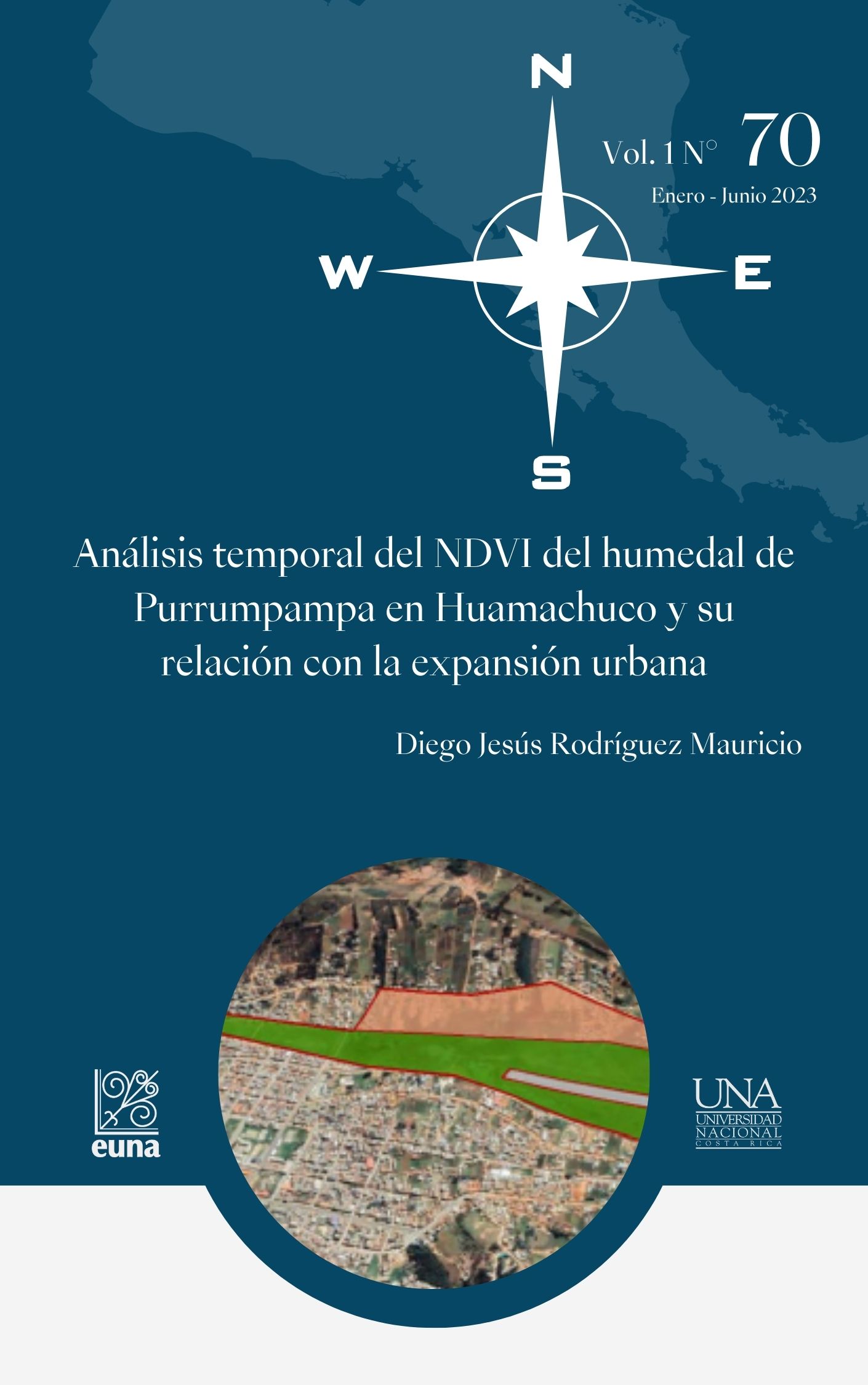
Análisis temporal del NDVI del humedal de Purrumpampa en Huamachuco y su relación con la expansión urbana
DOI:
https://doi.org/10.15359/rgac.70-1.16Palabras clave:
NDVI, Expansión urbana, humedalesResumen
La expansión urbana por lo general implica la ocupación informal de espacios naturales vulnerables, lo que conlleva al deterioro de estos ecosistemas. Este mismo fenómeno se presenta en el humedal de Purrumpama, ubicado en Huamachuco, una ciudad de la sierra liberteña del Perú. Por ello, el presente artículo planteó como objetivo realizar un análisis temporal de la flora presente en el humedal, contrastando los resultados obtenidos con un análisis temporal en Google Earth e identificando la relación con la expansión urbana. Para tal fin, se hizo uso imágenes satelitales Landsat 8 y Google Earth, delimitando el área de estudio según lo establecido por planes de la Municipalidad Provincial Sánchez Carrión. De esta manera, se determinó que existe una disminución constante de cobertura vegetal en las zonas Sur y Sur-este del humedal, calculando una pérdida de 74 792 m2 del humedal desde 2012 hasta 2021. Así mismo, se arguyó que las acciones ambivalentes de la municipalidad han legitimado la ocupación de viviendas y las acciones de control han sido ineficaces.
Referencias
Cruz, F. (2021). Patrones de expansión urbana de las megaurbes lati- noamericanas en el nuevo milenio. EURE, 47 (140). http://dx.doi. org/10.7764/eure.47.140.02
Galimberti, C. (2021). Nuevos procesos de expansión metropolitana: in- cremento acelerado de suelo urbano en el Área Metropolitana de Rosario (1990-2010). EURE, 47 (140). https://doi.org/10.7764/ eure.47.140.03
García, P., Domínguez, P., Corral, J., Pompa, M., Chávez, J., López, P., Rodríguez, R. y Padilla, J. (2021). Estimación de volumen forestal mediante imágenes de satélite Landsat 8 OLI en bosques templados mixtos. Investigación y Ciencia, 29 (81), 40-49.
HCO TV Huamachuco. (2021, 28 de mayo). MPSC CERCARÁ PAMPAS DE PURRUMPAMPA. https://www.facebook.com/hcotvhuamachuco/ videos/132812072157217
Instituto Geográfico Nacional. (2022). Descarga de Información Geoespa- cial. http://www.idep.gob.pe/
Municipalidad Provincial Sánchez Carrión y Pontificia Universi- dad Católica del Perú. (2016). Plan Urbano Específico “Pam- pas de Purrumpampa” 2016-2026. https://es.scribd.com/ document/478201535/P-E-PURRUPAMPA
National Aeronautics and Space Administration. (2019). Landsat 8. https:// eospso.nasa.gov/missions/landsat-8
Ojeda, N., Herrera, M., Bustamante, R., Morales, L., Carrillo, R., Bravo, L., Espinoza, A., Neira, Z., Calzadilla, S. & San-Miguel, J. (2019). Efecto de las áreas de entrenamiento y método del árbol para una clasificación precisa en bosques primarios de Araucaria Y Nothofa- gus en el sur de Chile: uso de datos LANDSAT e información auxi- liar. Interciencia, 44 (6), 347-354.
Tucker, C. (1979). Red and photographic infrared linear combinations for monitoring vegetation. Remote Sensing Environment, 8 (2), 127-150.
Rouse, J., Haas, R., Schell, J. & Ciervo, D. (1974). Monitoring vegetation systems in the great plains with ERTS. Third Earth Resources Tech- nology Satellite (ERTS). American Journal of Plant Sciences, 7(15),
-317.
RTC Noticias Huamachuco. (2022, 12 de enero). Increíble cerco de pam- pas de Purrumpampa-Huamachuco a punto de desaparecer a pocos meses de su ejecución por parte de la MPSC. https://www.facebook. com/rtcnoticiashuamachuco/posts/495461432184831
Rueda, F., Peñaranda, L., Velásquez, W.& Díaz, S. (2015). Aplicación de una metodología de análisis de datos obtenidos por percepción remota orientados a la estimación de la productividad de caña para panela al cuantificar el NDVI (índice de vegetación de dife- rencia normalizada). Corpoica. Ciencia y Tecnología Agorpecua- ria, 16, 25-40.
Salinas, C., Martínez, R. & Morales, M. (2017). Tendencia en el siglo XXI del Índice de Diferencias Normalizadas de Vegetación (NDVI) en la parte sur de la península de Baja California. Investigaciones geográ- ficas, 1(94), 01-09. DOI: 10.14350/rig.57214
Sánchez, J. (2018). Expansión urbana en la degradación de las lomas de Mangomarca en la asociación ecoturística, San Juan de Lurigan- cho-2017 [Tesis de licenciatura, Universidad Cesar Vallejo]. Reposi- torio Institucional Digital. https://hdl.handle.net/20.500.12692/21173
Tiedeman, J. (2015). Fenología y productividad primaria neta aérea de sis- temas pastoriles de Panicum maximun en el Dpto. Moreno, Santiago del Estero, Argentina, derivada del NDVI MODIS. Ecología Aplica- da, 14, 27-39.
United Nations International Children’s Emergency Fund. (2017). PERU Humanitarian Situation Report End of year 2017. https://www. unicef.org/peru/sites/unicef.org.peru/files/2019-12/UNICEF_Peru_ Humanitarian_Situation_Report_Year_End_2017.pdf
Vilela, M. y Moschella, P. (2017). Paisaje y expansión urbana sobre es- pacios naturales en ciudades intermedias. El caso de Purrumpampa en Huamachuco, La Libertad, Perú. Bulletin de l’Institut français d’études andines, 46 (3), 529-550.
Descargas
Publicado
Cómo citar
Número
Sección
Licencia
Política propuesta para Revistas que ofrecen Acceso Abierto
Los autores que publican en esta revista están de acuerdo con los siguientes términos:
a. Los autores conservan los derechos de autor y garantizan a la revista el derecho de ser la primera publicación del trabajo, bajo la Licencia https://creativecommons.org/licenses/by-nc-sa/4.0/deed.es, que permite a otros compartir con un reconocimiento de la autoría del trabajo y la publicación inicial en esta revista.
b. Los autores pueden establecer por separado acuerdos adicionales para la distribución no exclusiva de la versión de la obra publicada en la revista (por ejemplo, situarlo en un repositorio institucional o publicarlo en un libro), con un reconocimiento de su publicación inicial en esta revista. Esos acuerdos adicionales deben respetar los términos de la licencia: es decir: no involucrar fines de lucro y compartir con la misma licencia.
c. Se anima a los autores a archivar el post-print o versión de editor/PDF en repositorios de acceso abierto.


 REVGEO se encuentra bajo la licencia https://creativecommons.org/licenses/by-nc-sa/4.0/deed.es

